Homeschool Creations

Thursday, September 9, 2010

Learning About Venezuela ~ Lesson Plans and Links

Venezuela is the northernmost country of South America and a little larger than the state of Texas and Oklahoma put together. It is home to Angel Falls, the highest waterfall in the world. Venezuela is also the wealthiest nation in Latin America because of the petroleum/oil reserves that are found in the country {second in size to those in the Persian Gulf area}.

There are several different areas in Venezuela: beautiful beaches, the Andes mountains, plains {llanos}, rainforests, and the highlands {tepui}. We talked a little bit about everything this week: Columbus, the first explorer to visit Venezuela in 1498; the religion and languages of the country; Angel Falls; and Simon Bolivar, the man that led the revolt that ended the Spanish rule of Venezuela.

You can view the other countries that we’ve studied from South America on my South America geography page.

Week 1 Layout

Monday

  • Review our South America song from Geography Songs {see words below}
  • Use atlas and globe to locate the country of Venezuela; read in the atlas about Venezuela
  • Read one of our books from our bookshelf about Venezuela.

  South America

    Argentina, Venezuela and Colombia,

    Ecuador, Peru and Chile and Bolivia,

    Uruguay and Paraguay, Brazil and Guyana

    and Suriname ~

    These are the countries of South America.

    The French have French Guiana.

    The British have the Falkland Islands.

    Brazil is the biggest country and

    Chile is the longest.

Tuesday

  • Learn {and review} some terms: mountains, beaches, plains, rainforest, tabletop plateaus
  • Independent reading from bookshelf
  • Filled out the map of Venezuela notebooking page

Mapping Venezuala   Click on thumbnail to download pdf file

Wednesday

  • Review geography song
  • Talked about languages and religions of Venezuela
  • Independent reading 
Thursday

Week 2 Layout

Monday

Flag of Venezuala 

Click on thumbnail to download pdf file

Tuesday

  • Learned about Jimmy Angel and Angel Falls
  • Watched this video of Angel Falls and also this one {amazing}
  • Read together one of books from bookshelf
Wednesday Thursday
  • Summarized one of our reading books and copy summary/dication
  • Cooking ~ Platanos Fritos
  • Added our notebooking pages to our binder and stamped our passports!

Books & Resources


Resources and Websites

Jolanthe Signature affiliate button

Labels: , , ,

Tuesday, September 7, 2010

Perusing Peru ~ Lesson Plans and Links for Learning about Peru

I know…it’s a bad title. But can you blame me? :)

One of the last countries that we learned about in South America was Peru. Peru is the third largest country in South America and nearly half of the country is covered by the Amazon jungle. There are many plants and animals found in Peru that are not found anywhere else on earth. The Andes mountains also run through the country of Peru.

You can view the other countries that we’ve studied from South America on my South America geography page.

Week 1 Layout

Monday

  • Review our South America song from Geography Songs {see words below}
  • Use atlas and globe to locate the country of Peru; read in the atlas about Peru
  • Read one of our books from our bookshelf about Peru.

  South America

    Argentina, Venezuela and Colombia,

    Ecuador, Peru and Chile and Bolivia,

    Uruguay and Paraguay, Brazil and Guyana

    and Suriname ~

    These are the countries of South America.

    The French have French Guiana.

    The British have the Falkland Islands.

    Brazil is the biggest country and

    Chile is the longest.

Tuesday

  • Review geography song
  • Learn {and review} some terms: mountains, mountain pass, lake, desert, rain forest, jungle
  • Independent reading from bookshelf
  • Filled out the map of Peru notebooking page

Mapping Peru  Click on thumbnail to download pdf file

Wednesday

Thursday

Week 2 Layout

Monday

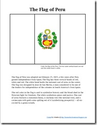
Flag of Peru Click on thumbnail to download pdf file

Tuesday

Wednesday Thursday
  • Summarized one of our reading books and copy summary/dication
  • Added our notebooking pages to our binder and stamped our passports!

Books & Resources


Resources and Websites

Jolanthe Signature affiliate button

Labels: , , ,

Tuesday, July 27, 2010

Learning About Chile ~ Lesson Plans and Links

While Brazil is the largest country in South America, Chile is the longest. Off the southern coast there are thousands of small islands. We had fun learning that the seasons in Chile are reversed from those in the Northern Hemisphere {summer is December to March and winter is June to August}, comparing the Chilean flag to one of the US state flags {Texas} and figuring out which came first.

We talked a little about the Inca’s and Chile’s independence from Spain, about the five regions of Chile, and also about earthquakes and plates. We also used the time to talk a bit about Darwin and the theory of evolution {his visit to Chile after an earthquake} ~ maybe not typical geography studies, but it fit in when we were studying. You can view the other countries that we’ve studied from South America on my geography page.

Week 1 Layout

Monday

  • Review song about South America from Geography Songs {see words below}
  • Use atlas and globe to locate Chile; read in the atlas about Chile
  • Read one of our books from our bookshelf about Chile.

      South America

    Argentina, Venezuela and Colombia,

    Ecuador, Peru and Chile and Bolivia,

    Uruguay and Paraguay, Brazil and Guyana

    and Suriname ~

    These are the countries of South America.

    The French have French Guiana.

    The British have the Falkland Islands.

    Brazil is the biggest country and

    Chile is the longest.

Tuesday

  • Learn {and review} some terms: inlets, fjords, desert, strait, island, continental plate
  • Read together book on Chile  
  • Learned about the flag of Chile and completed our notebooking sheet

    Flag of Chile 

    Click on thumbnail to download pdf file

Wednesday

Thursday

  • Reviewed geography song
  • Spent time ‘sightseeing’ on the Time for Kids ~ Chile page. 
  • Read together book on Chile

Week 2 Layout

Monday

  • Quick review about what we covered last week.
  • Visited the National Geographic Kids site to learn more about Chile
  • Independent reading from shelf
  • Filled out the map of Chile using our notebooking page.

     Mapping Chile Click on thumbnail to download pdf file

Tuesday

Wednesday Thursday

Resources and Websites

Jolanthe Signature affiliate button

Labels: , , ,

Tuesday, July 6, 2010

Brazil and Rain Forests ~ Lesson Plans & Links

The first week in our study of Brazil we focused more on the country itself and during our second week we learned more about rainforests. Brazil is the largest country in South America ~ almost half of the land in the continent is within the border of Brazil {pretty amazing, when you think about it!}.

The Amazon river also flows through the country of Brazil, making it a great opportunity to read the book Afternoon on the Amazon by Mary Pope Osborne with all of the kids and use the Rain Forests companion guide in our study. You can view the other countries that we’ve studied from South America on my geography page.

Week 1 Layout

Monday

  • Review song about South America from Geography Songs {see words below}
  • Use atlas and globe to locate Brazil; read in the atlas about Brazil
  • Read one of our books from our bookshelf about Brazil.

      South America

    Argentina, Venezuela and Colombia,

    Ecuador, Peru and Chile and Bolivia,

    Uruguay and Paraguay, Brazil and Guyana

    and Suriname ~

    These are the countries of South America.

    The French have French Guiana.

    The British have the Falkland Islands.

    Brazil is the biggest country and

    Chile is the longest.

Tuesday

  • Review geography song
  • Learn {and review} some terms: rain forest, river, jungle, pampas, grasslands, wetlands, plateaus, and plains 
  • Reading together book on Brazil {Amazon River} ~ Afternoon on the Amazon 
  • Filled out the map of Brazil using our notebooking page. We also shaded in the rainforest area.

mapping brazil notebooking sheet

 Click on thumbnail to download pdf file

Wednesday

 flag of brazil notebooking sheet

Click on thumbnail to download pdf file

Thursday

Week 2 Layout

Rainforest Diorama

from McKenna’s rainforest diorama

Monday

Tuesday

Wednesday
  • Read chapters 5-6 from Rain Forests
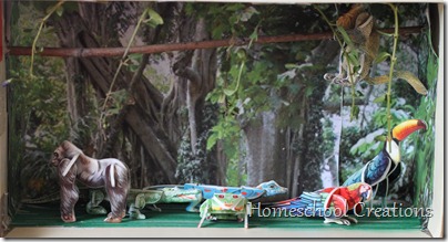
  • McKenna put together a diorama of a rainforest. We had some 3 dimensional rainforests animals and she wanted to make one to go along with what we were learning. It wasn’t super-detailed, but she did {most of it} on her own. I printed off a scene from the rainforest and she used the picture to line the box and then added some branches and vines along with the animals to decorate it.

Rainforest Diorama   Rainforest diorama

Thursday
  • Review geography song
  • Read chapter 7 from Rain Forests
  • Put our lapbook pieces on a cardstock sheet to add to our binder.
  • Summarized one of our reading books and copied summary
  • Added our notebooking pages to our binder and stamped our passports!

Books We Used

Resources and Websites

Jolanthe Signature affiliate button

Labels: , ,

Sunday, June 20, 2010

Learning About Argentina ~ Lesson Plans & Links

We’ve officially ‘landed’ in South America and our travels are starting in Argentina! Here are a few fun facts about Argentina before sharing about our time in Argentina.

Argentina is the eighth largest country in the world {and the second largest in South America ~ behind Brazil}. It is roughly the size of the U.S. east of the Mississippi River, about 1/3 the size of the United States. The border between Argentina and Chile is well-defined since the Andes Mountains provide a natural border {over 3,000 miles long!}.

The climate has extremes ranging from subtropical in the north to arid/sub-Antarctic in the far south. You can sit on warm beaches…or watch ice break off glaciers, depending on where you are visiting in the country.

You can view the other countries that we’ve studied in South America on my South America geography page.

Here’s a peek at our ‘travels’:

Week 1 Layout

Monday

  • Introduce new song about Argentina from Geography Songs {see words below}
  • Use atlas and globe to locate Argentina; read in the atlas about Argentina
  • Read one of our books from our bookshelf about Argentina

South America

Argentina, Venezuela and Colombia,

Ecuador, Peru and Chile and Bolivia,

Uruguay and Paraguay, Brazil and Guyana

and Suriname ~

These are the countries of South America.

The French have French Guiana.

The British have the Falkland Islands.

Brazil is the biggest country and

Chile is the longest.


Tuesday

  • Review geography song
  • Learn {and review} some terms: plains, pampas, mountains
  • Independent reading from bookshelf
  • Filled out the map of Argentina using our notebooking page

image

 Click on thumbnail to download pdf file

Wednesday

  • Review geography song
  • Watched a LOT of video clips from World Zone Live {there are some great clips here}
  • Independent reading 
Thursday
  • Review geography song
  • Children Just Like Me book {Carlitos, p.12-13} and notebooking page
  • Talked about the variety of geography features in Argentina ~ from beaches to the areas close to the South Pole; mountains to plains
  • Read book together on Argentina {from our bookshelf}

Week 2 Layout

Monday

image

Click on thumbnail to download pdf file

Tuesday

  • Review geography song
  • Watched a video with the national anthem
  • Talked about some of the animals in Argentina ~ there is a huge variety of them! The mountains are home to llamas and condors, the southern part of Argentina has cougars and pudu {the world’s smallest deer}, the coast of Patagonia has elephant seals, sea lions, and penguins. The waters off the coast have dolphins, whales and orcas.
  • Read together one of books from bookshelf

Wednesday

Thursday
  • Review geography song
  • Summarized one of our reading books and copy summary/dication
  • Bought Dulce de Leche…because mommy was too lazy to make it. :)
  • Added our notebooking pages to our binder and stamped our passports!

Books We Used

Resources and Websites

 Jolanthe Signature affiliate button

Labels: , , ,